Wisel Cemetery
Fillmore County Minnesota
In keeping with the USGenWeb policy of providing free genealogy information
on the Internet, the following cemetery data may be freely used by non-commercial
entities, as long as this message remains on all copied material. These
electronic pages may NOT be reproduced in any format for profit or presentation
by other organizations. Persons or organizations desiring to use this material
for purposes other than as stated above must contact the submitter or the
Fillmore County MNGenWeb Project coordinator.
Return to Cemetery Transcriptions Online
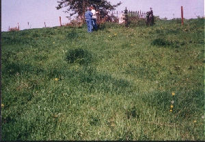
The Wisel Cemetery is located on private property in a farm pasture
in Preble Township. These photos were taken May 10, 1998.
Wisel Cemetery
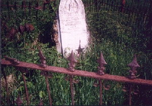
One stone surrounded by an ornate but falling down wrought-iron fence.
|
Julia Wisel
Aged 89 years
and her son
David Wisel
aged 56 years
Jonathan Wisel
son of
Ira Wisel aged 12 yrs
All of whom perished
in the f_______
night of Aug 6, 1866
also
Ezra Wisel
son of
David & Jerusha
Wisel
who died a soldier
Nov 20, 1860
aged 22 yrs
|
The Wisel marker has been broken in two and cemented back together. Cement
obliterates the writing on the line "in the f____." It most likely said "in
the flood" as this family died in what is known as the "Wisel Flood" on Aug.
6, 1866. There is a small American flag and a veteran's marker for Ezra
who died earlier as a soldier in the Civil War. David Wisel's wife Jerusha
was the only one who survived the flood. David Wisel and family came to Preble
Township in 1854 from Cattaraugus County in western New York state.
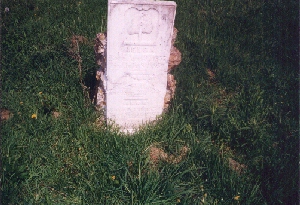
Outside the fence about 20 feet to the southwest is another stone.
|
Helga
Born Apr 9 1857
Died July 8 1859
John
Born Feb 18__
Died Sep 22 1860
Anna
Born Oct 10 1854
Died Mar 11 1862
Children of
Knud K. Lerohl
|
Today this surname Lerohl is spelled Lerol.
From Bruce Larson September, 2003:
Directions to the cemetery are S of Mabel on Hwy. 43 about 8 miles to Fillmore
Co. Hwy. 12. West on 12 about 3½ miles. (½ mile east of Amherst
Twp.) Then S through a cow pasture ½ mile. GPS coordinates: N 43°
37.899' W 91° 50.397'. According to local residents, there used to be
many more tombstones in the cemetery. Perhaps 10 to 12. Maybe they are still
there but not noticable. This was probably a very early cemetery used by
the locals prior to the church cemeteries being established. The two stones
there now, the Wisel stone and the children of Knud Knudson Lerol are about
70 feet apart leaving room for plenty of graves. Knud Lerol, at least in
1896, lived a couple of miles west of the cemetery.
You are the [an error occurred while processing this directive] visitor to this page.
Copyright  Marge Utley 1998