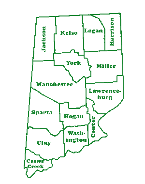
- INDEX - | Caesar Creek |
---|---|
Center, | |
Clay, | |
Harrison, | |
Hogan, | |
Jackson, | |
Kelso, | |
Lawrenceburg, | |
Logan, | |
Manchester, | |
Miller, | |
Sparta, | |
Washington, | |
York |
AREA | POPULATION | MAJOR HIGHWAYS |
---|---|---|
(Total)--307 Square Miles | 1810--7,310 | Interstate 74 |
(Land)---305 Square Miles | 1820--11,468 | Interstate 275 |
(Water)---1 Square Mile | 1840--19,327 | Indiana State Highway 1 |
Miscellaneous | 1860--24,406 | Indiana State Highway 46 |
Households (2000)--16,832 | 1880--26,671 | Indiana State Highway 48 |
Families (2000)--12,775 | 1900--22,194 | Indiana State Highway 56 |
Population Density 151 People Per Square Mile | 1920--20,033 | Indiana State Highway 62 |
1940--23,053 | Indiana State Highway 101 | |
1960--28,674 | Indiana State Highway 350 | |
1980--34,291 | US Highway 50 | |
2000--46,109 | US Highway 52 | |
2007--49,663 |
TOWNS and VILLAGES |
---|
Aurora | Bright | Dillsboro | Farmers Retreat |
Greendale | Guilford | Hidden Valley | Lawrenceville |
Logan | Manchester | Moores Hill | New Alsace |
Saint Leon | Sparta | West Harrison | Wilmington |
Wiseburg |
PUBLIC SCHOOLS | ||
---|---|---|
Sunman Dearborn Community School Corporation | ||
Elementary; | Middle; | High School; |
Sunman K-4 Bright1-4 North Dearborn K-4 | Grades 7-8 | East Central High School |
Lawrenceburg Community School Corporation | ||
Primary (Pre K-2) Central Elementary   (3-5) | Greendale Middle School | Lawrenceburg High School |
South Dearborn Community School Corporation | Aurora (pre schl-6) Dillsboro (K-6) Manchester(K-6) Moores Hill (K-6) | South Dearborn - (Aurora) | South Dearborn - (Aurora) |
PAROCHIAL SCHOOLS |
---|
Saint Paul Catholic- New Alsace | Saint Mary Catholic- Aurora |
Saint Lawrence Catholic- Lawrenceburg | Saint John Lutheran- Aurora |