

East Baton Rouge Parish
LAGenWeb

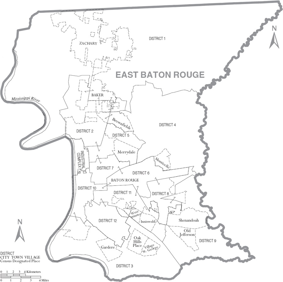
Map courtesy of Wikimedia, where the larger, original map is available
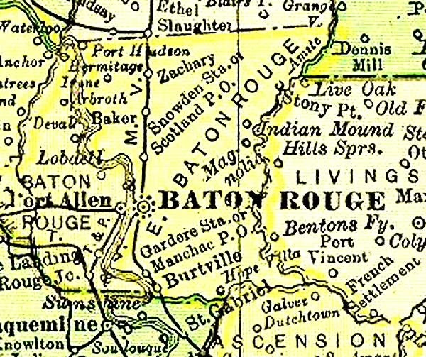
1895 Rand McNally Atlas map
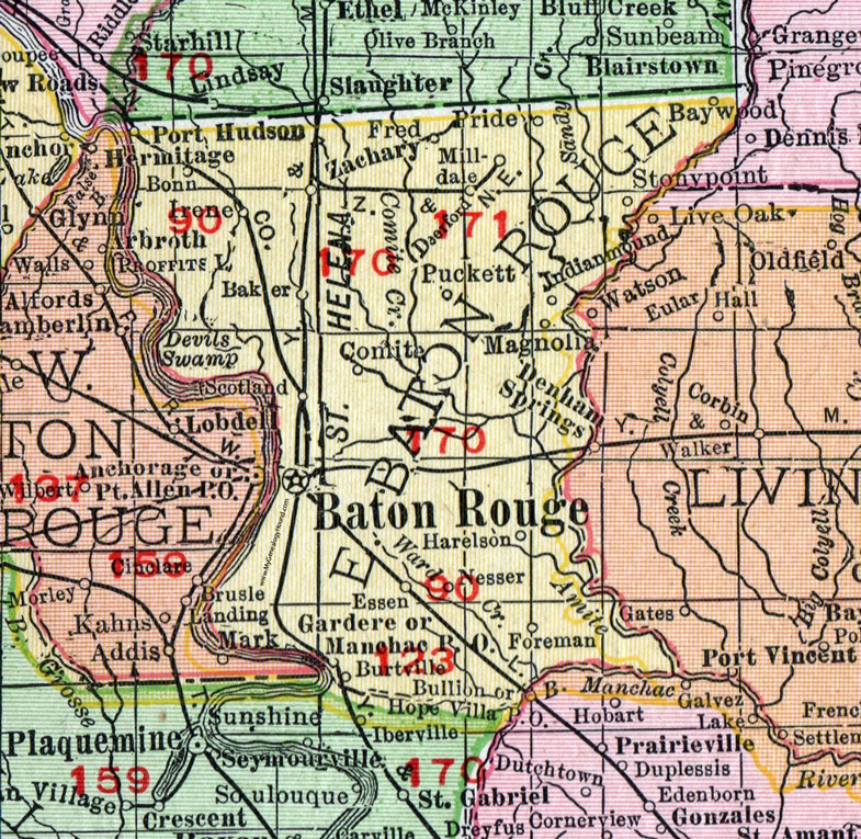
1911 map courtesy of My Genealogy Hound, where the larger, original map is available
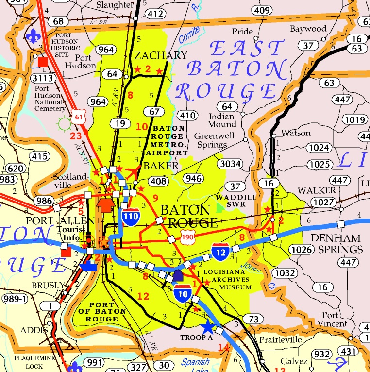
Map courtesy of University of Louisiana, where the larger, original map is available
Baker, a village in the northwestern part of East Baton Rouge parish, is on a branch of the Amite river about 10 miles north of Baton Rouge, and is a station on the main line of the Yazoo & Mississippi Valley R. R. It has a money order post office and one free rural delivery route. Its population is about 100.
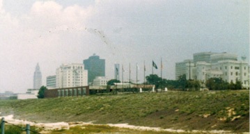 Baton Rouge, the capital of the state and the seat of justice of East
Baton Rouge parish, is located on the east bank of the Mississippi
river, 120 miles above New Orleans by river, but only 68 miles "as the
crow flies." It was founded by the French in 1719 and occupies the first
high" lands the voyageurs found in their ascent of the great river. The
words baton rouge translated into English mean "red stick." and
according to Du Pratz this name was derived from a large cypress tree
which, stood on the site of the city when the French first visited the
place. This tree had been shorn of nearly all its branches and most of
its bark, and as the natural color of the wood of the cypress is red,
the denuded trunk of this tree presented the appearance of a gigantic
red stick or baton. Another account says the name was taken from a red
stake planted on the river bank to mark the boundary line between the
hunting grounds of the Houma and Bayou Goula Indians.
Baton Rouge, the capital of the state and the seat of justice of East
Baton Rouge parish, is located on the east bank of the Mississippi
river, 120 miles above New Orleans by river, but only 68 miles "as the
crow flies." It was founded by the French in 1719 and occupies the first
high" lands the voyageurs found in their ascent of the great river. The
words baton rouge translated into English mean "red stick." and
according to Du Pratz this name was derived from a large cypress tree
which, stood on the site of the city when the French first visited the
place. This tree had been shorn of nearly all its branches and most of
its bark, and as the natural color of the wood of the cypress is red,
the denuded trunk of this tree presented the appearance of a gigantic
red stick or baton. Another account says the name was taken from a red
stake planted on the river bank to mark the boundary line between the
hunting grounds of the Houma and Bayou Goula Indians.
For some years the growth of the settlement at Baton Rouge was slow, but after the Western Company surrended its charter in 1732 important additions were made by the arrival of immigrants, and when the Acadians were driven from their homes in Nova Scotia about 80 of the exiles settled at Baton Rouge or in the immediate vicinity. At the time France ceded Louisiana to Spain in 1762, certain territory east of the Mississippi, including Baton Rouge, was ceded to Great Britain, but when, in May, 1779, Spain declared war against England, Gov. Galvez of Louisiana set about the recovery of this territory (See Spanish Conquest), and on Sept. 21, 1779, the English fort at Baton Rouge capitulated. With the exception of the few months that it belonged to the short-lived republic of West Florida, Baton Rouge remained a Spanish pos- session until it passed into the hands of the United States, so that the flags of four nations — France, England, Spain and the United States — have in turn floated over Louisiana's capital city. At the battle of New Orleans, Jan. 8, 1815, Baton Rouge and the near-by plantations furnished two companies of volunteers, numbering 168 men, who performed their duties bravely and well.
The first steamboat that ever visited Baton Rouge was the "New Orleans," which arrived there on Jan. 8, 1812, having made the trip from Pittsburg, Pa., in 241 hours — a speed which at that time was considered little short of marvelous. Ten years later, or during the year 1822, no less than 83 steamers, 174 barges and 441 flatboats touched at her wharves, which will give some idea of the growth and importance of her river commerce at that period.
On Jan. 16, 1816, the Louisiana legislature passed an act providing that "All free white male persons above the age of 21 years, who are freeholders, householders or landowners, within the following limits, to wit: from the mouth of the bayou at the upper part of the town of Baton Rouge (called Garcia's Bayou) and extending on the main branch of said bayou to the distance of 40 arpents from the Mississippi, and below commencing at the Mississippi on the town line of the tract of land claimed by Madam Marion, and pursuing the direction of said line to the distance of 40 arpents from the Mississippi, are hereby authorized to meet and elect five selectmen annually," etc. Under this act an election was accordingly held, and by the legislative enactment of July 6, 1817, the town received its first charter of incorporation. The council provided for in the act met for the first time on April 13, 1818, and organized by the election of the following officers: William Williams, president of the council and mayor ex-officio; Thomas C. Stanard, clerk: D. E. Pintado, treasurer and collector; and Pierre Jautin, police officer. The first ordinance passed by the council related to taxes and licenses; the second provided for certain street improvements; the third ordered the construction of a combined town hall and market house, and the fourth provided for the punishment of "all disorderly and drunken persons." At the third meeting the council ordered "all bar-rooms, saloons, grogshops, cabarets, billiard rooms and bowling alleys" to be closed on Sunday. This ordinance is said to be the first Sunday law ever passed in the Mississippi valley.
Political and military considerations in 1819 made it necessary for the United States government to quarter a large body of troops in the vicinity of the mouth of the Mississippi river. After looking over the ground the war department selected Baton Rouge because of its healthful location on the first bluffs above the mouth of the river, and the following year the garrison and arsenal buildings necessary for an encampment and military post were completed and occupied. Since 1886 these buildings have been occupied by the Louisiana State University and the Agricultural and Mechanical College, one of the best educational institutions of its kind in the South.
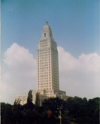 By the provisions of the constitution of 1845, Baton Rouge became the
capital of the state in 1849 (See Capital), and consequently the city
has been since that time more or less of a political storm center. Being
the capital, it probably suffered more heavily during the Civil war and
the stormy days of reconstruction that followed than it otherwise would.
At the close of the reconstruction period the city, and the parish in
which it is located, were burdened with a heavy debt, which for some
years proved a serious handicap to progress. The population in 1870, the
first U. S. census after the war, was 6,496. With the adjustment of the
old debt the development and increase in population were rapid, and at
the present time (1909) the population is estimated in round numbers at
26,000, while the city is practically on a cash basis, the bonded
indebtedness being only about S300,000, a good portion of which was
incurred by the provisions for the purchase of the waterworks by the
city at the expiration of the water company's contract in 1908. Bank
deposits increased from a little over $1,000,000 in 1900 to over
$2,000,000 in 1907; during the same period the city tax roll increased
from 82,236,000, in round numbers, to over $4,000,000, and the post
office receipts from $17,021 to nearly $31,500. The city has a good
public school system; five banking institutions; four trunk lines of
railroad; a large river trade; well paved streets and good sidewalks; a
good sewer system; free mail delivery, with rural routes to all parts of
the parish; a fire department with electric fire alarm system; good
street railway service; daily and weekly newspapers; gas and electric
lighting systems; hotels and theaters, and churches of all the leading
denominations. The principal public buildings and institutions are the
state capitol, the Federal courthouse and post office, parish
court-house, city hall, state university, school for deaf mutes, school
for the blind, and the agricultural experiment station. The principal
manufactures are sugar, cotton, and lumber. Baton Rouge was the home of
Gen. Zachary Taylor, 12th president of the United States, and of his
son, Gen. Richard Taylor, who was one of the most dashing commanders in
the Confederate army during the Civil war.
By the provisions of the constitution of 1845, Baton Rouge became the
capital of the state in 1849 (See Capital), and consequently the city
has been since that time more or less of a political storm center. Being
the capital, it probably suffered more heavily during the Civil war and
the stormy days of reconstruction that followed than it otherwise would.
At the close of the reconstruction period the city, and the parish in
which it is located, were burdened with a heavy debt, which for some
years proved a serious handicap to progress. The population in 1870, the
first U. S. census after the war, was 6,496. With the adjustment of the
old debt the development and increase in population were rapid, and at
the present time (1909) the population is estimated in round numbers at
26,000, while the city is practically on a cash basis, the bonded
indebtedness being only about S300,000, a good portion of which was
incurred by the provisions for the purchase of the waterworks by the
city at the expiration of the water company's contract in 1908. Bank
deposits increased from a little over $1,000,000 in 1900 to over
$2,000,000 in 1907; during the same period the city tax roll increased
from 82,236,000, in round numbers, to over $4,000,000, and the post
office receipts from $17,021 to nearly $31,500. The city has a good
public school system; five banking institutions; four trunk lines of
railroad; a large river trade; well paved streets and good sidewalks; a
good sewer system; free mail delivery, with rural routes to all parts of
the parish; a fire department with electric fire alarm system; good
street railway service; daily and weekly newspapers; gas and electric
lighting systems; hotels and theaters, and churches of all the leading
denominations. The principal public buildings and institutions are the
state capitol, the Federal courthouse and post office, parish
court-house, city hall, state university, school for deaf mutes, school
for the blind, and the agricultural experiment station. The principal
manufactures are sugar, cotton, and lumber. Baton Rouge was the home of
Gen. Zachary Taylor, 12th president of the United States, and of his
son, Gen. Richard Taylor, who was one of the most dashing commanders in
the Confederate army during the Civil war.
For a time, during the French domination, Baton Rouge was called Dironbourg, from Diron d'Artaguette (q. v.). The British called it New Richmond, but the name Baton Rouge, given by the French, prevailed after the conquest by Galvez and has been retained to this day.
Baywood, a post-hamlet in the northeastern part of East Baton Rouge parish, is situated on the Amite river, about 5 miles east of Pride, the nearest railroad town.
Burtville, a village and station in the southern part of East Baton Rouge parish, is on the Yazoo & Mississippi Valley R. R., about 10 miles southeast of Baton Rouge, the parish seat. It has a money order post office and a population of about 150.
Central
Comite, a post-hamlet in the eastern part of East Baton Rouge parish, is situated near Comite creek about 8 miles northeast of Baton Rouge, the parish seat and nearest railroad town.
Deerford, a little village in the northern part of East Baton Rouge parish, is a station on the Zachary & Northeastern R. R., about 7 miles east of Zachary and 16 miles northeast of Baton Rouge. It has a money order post office and in 1900 had a population of 25.
Foreman, a post-hamlet in the southeastern part of East Baton Rouge parish, is on a tributary of the Amite river, about 5 miles northeast of Kleinpeter, the nearest railroad station.
Fred, a post-hamlet in the northern part of East Baton Rouge parish, is a station on the Zachary & Northeastern R. R., about 5 miles cast of Zachary and 13 miles northeast of Baton Rouge.
Greenwell Springs
Inniswold
Irene, a post-village in the northwestern part of East Baton Rouge parish, is a station on the line of the Louisiana Railway & Navigation company, 12 miles northwest of Baton Rouge, the parish seat.
Klienpeter
Lockhart
Magnolia, a post-hamlet of East Baton Rouge parish, is situated on a confluent of the Amite river, about 5 miles north of Denham Springs, the nearest railroad station, and 15 miles northeast of Baton Rouge, the parish seat.
Milldale, a post-village in the northern part of East Baton Rouge parish, is a station on a short line of railway that connects with the Yazoo & Mississippi Valley R. R. at Zachary.
Monticello
Oak Hills Place
Old Jefferson
Port Hudson, an incorporated town in the northwestern part of East Baton Rouge parish, is located on the Mississippi river and is a station on the line of the Louisiana Railway & Navigation company, about 15 miles from the city of Baton Rouge. It has a money order post office, express, telegraph and telephone facilities, several good stores, and is an important shipping point, hundreds of bales of cotton being marketed here every year. The population in 1900 was 300. Port Hudson was one of the Confederate strongholds on the Mississippi river in the early part of the war between the states. Several Federal gunboats were destroyed or damaged here in March, 1863, when Farragut attempted to pass the batteries with his fleet, and the place surrendered only after a long and painful siege, and not then until after the fall of Vicksburg.
Pride, a post office in the northeastern part of East Baton Rouge parish, is a station on the Zachary & Northeastern R. R., about 20 miles northeast of Baton Rouge, the parish seat.
Puckett, a post-station in the central part of East Baton Rouge parish, is about 4 miles southwest of Deerford, the nearest railroad station, and 10 miles northeast of Baton Rouge, the parish seat.
Shenandoah
Stevensdale
Westminster
Zachary, one of the largest incorporated towns in East Baton Rouge parish, is situated at the junction of the Yazoo & Mississippi Valley and the Zachary & Northeastern railroads, in the northern part of the parish. It is one of the large cotton shipping and trading centers of the parish, has a bank, a money order post office, telegraph and express offices, good schools, fine mercantile establishments, cotton gins and other industries, and in 1900 reported a population of 465.
Initial list extracted 12 Nov 2020 by Norma Hass, from Louisiana; comprising sketches of counties, towns, events, institutions, and persons, edited by Alcee Fortier, published in 1909, volumes 1 & 2.
East Baton Rouge LAGenWeb Copyright
Design by Templates in Time
This page was last updated 05/29/2022