|
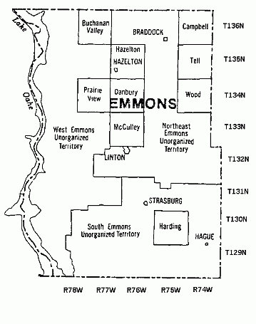
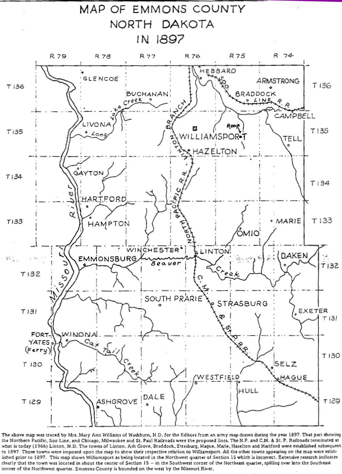
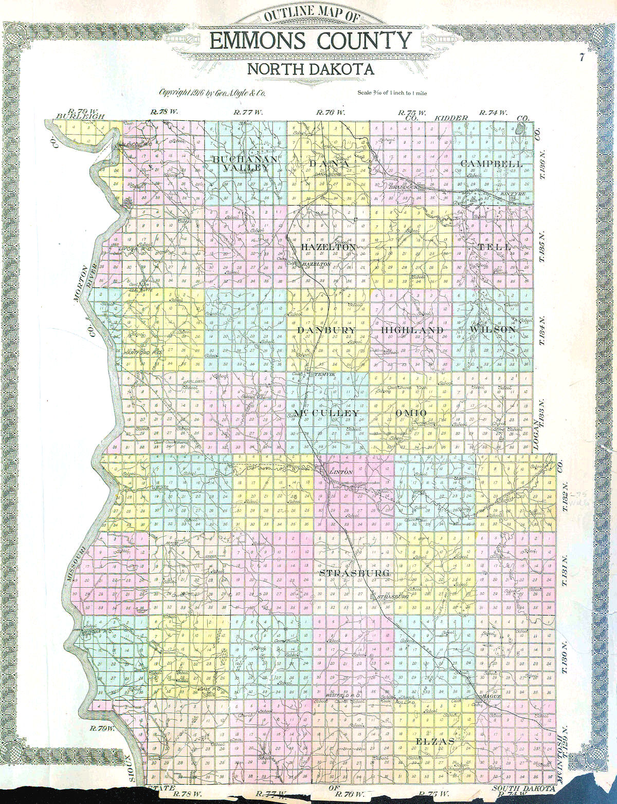
The names of the Emmons County Townships have been difficult to document given the available resources. Sometimes names conflict and at times they appear to be confused with school district names. With the excellent help of Cynthia Maier, the below lists the Township and Range numbers along with any documented Township name. Appended is a brief list of those places where the Township name is mentioned. Links to any available Township maps are also below. T136 R74 Campbell - 1897, 1916, 1992 Maps; 1920 Census T136 R75 Cherry Grove School - 1910, 1920 (Mistakenly called Cheng), 1930 Census T136 R76 Dana - 1916 Map; 1920, 1930 Census T136 R77 Buchanan Valley - 1916 & 1992 Maps; 1920, 1930 Census; Buchanan - 1897 Map T136 R78 T136 R79 T135 R74 Tell - 1897, 1916, 1992 Maps; 1920, 1930 Census T135 R75 Lincoln School - 1920, 1930 Census T135 R76 Hazelton - 1916 & 1992 Maps; 1920, 1930 Census T135 R77 Williamsport School - 1920 Census T135 R78 T135 R79 T134 R74 Wood - 1992 Map, 1930 Census; Wilson - 1916 Map, 1920 Census T134 R75 Phelman - 1930 Census; Highland - 1916 Map, 1920 Census T134 R76 Danbury - 1916 & 1992 Maps; 1920, 1930 Census T134 R77 Liberty - 1920, 1930 Census; Prairie View - 1992 Map T134 R78 Gayton - 1930 Census T134 R79 T133 R74 Marie School - 1920 Census T133 R75 Omio - 1916 Map; 1920, 1930 Census T133 R76 McCulley - 1916, 1992 Maps; 1920 Census T133 R77 Sand Creek School - 1920, 1930 Census T133 R78 Hampton - 1930 Census; Marie - 1897 Map T133 R79 T132 R74 Dakem School - 1910, 1920 Census T132 R75 Wells School - 1910, 1920, 1930 Census T132 R76 Winchester School - 1920, 1930 Census T132 R77 South Prairie School - 1920 Census T132 R78 T132 R79 T131 R74 Odessa School - 1920, 1930 Census T131 R75 Exeter School - 1920, 1930 Census T131 R76 Strasburg - 1916 & 1992 Maps; 1920, 1930 Census; South Prairie - 1897 Map T131 R77 T131 R78 T131 R79 T130 R74 T130 R75 Harding - 1992 Map T130 R76 T130 R77 Union School - 1910, 1920 Census; Krassna - 1930 Census T130 R78 T130 R79 Winona - 1910 Census T129 R74 Selz School - 1920 Census T129 R75 Elzas - 1916 & 1992 Maps; 1920, 1930 Census; Hull - 1897 Map; T129 R76 T129 R77 T129 R78 T129 R79 Note: 1910 and to some extent the other census reports, indicate the census may have been conducted by School District as some names were used for several township/ranges. For example; in 1910 the name of Winona School District is used for townships 130-79, 131-78, and 131-79. This makes it very difficult to determine the name of a township, if any. County Township Map (Date Unknown) 1897 County Township Map 1916 County Township Map 1993 County Township Map |