

Mahoning County Links:
You are the
visitor to this
page
Last Modified & links checked

Monday, 07-May-2018 17:46:05 CDT


Hello! from Your Mahoning County Coordinator

My name is Mary Ann Hetrick. I am the person responsible for Mahoning County. If you have any problems with the links on this page feel free to let me know.
If you would like to help we do need volunteers to do look ups, and to transcribe the census rolls for Mahoning County. This will be through the USGenWeb Census Project.
I have also started a photo album of historical buildings and people. If you have any old pictures you would like to see in this project, or if you have any ideas as to what you would like to see on the page, feel free to email me at:
I will not be avaiable for lookups in Mahoning County. At the present time, my personal obligations will not allow me to do any research. I will try to find time to transcribe records and add them to these pages.
When you do email me please add Mahoning County in the subject line. I have three counties in Ohio and this will help to keep mail separated.
Enjoy your visit to the Mahoning County OHGenWeb project. This is a part of the USGenWeb and OHGenWeb projects. -- Mary Ann Hetrick
- Named for: Native American word meaning "at the salt licks"
Established: Act - March 1, 1846
2004 Population: 249,755
Land Area: 415.3
County Seat: Youngstown City
Mahoning County was formed on March 1, 1846, from Columbiana and Trumbull Counties. The two upper tiers of townships, taken from Trumbull County, include: Austintown, Berlin,Boardman, Canfield, Coitsville, Ellsworth, Jackson, Milton, Poland and Youngstown. Each is five miles square and was surveyed and sold as part of the Connecticut Western Reserve .
The lower tier of townships, taken from Columbiana County, includes: Beaver, Goshen, Green, Smith and Springfield. Each is six miles square and were surveyed as the Congress Lands Northeast by the federal government and sold through the Steubenville Land Office.
"There are fifteen townships in the county; the five southernmost, viz., Smith, Goshen, Green, Beaver and Springfield, originally formed part of Columbiana, and the others the southern part of Trumbull, the last of which are within the Western Reserve. Area about 420 square miles."1
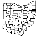
Mahoning County's Ohio neighbors:
- Trumbull County (to the North)
- Portage (to the Northwest)
- Stark Counties (to the Southwest)
- Columbiana County (to the South)
Pennsylvania Neighbors You might have connections to:
- Lawrence (to the East)
- Mercer Counties (to the Northeast)
- Beaver County, (to the Southeast)
Archived surnames, queries, and researchers entered before September 1998
Updated Friday, September 07, 2007
Mahoning County Queries
Join the Mailing Lists!
![]()
Mahoning County, OH Mailing List
OHMAHONI. A mailing list for anyone wishing to discuss history, research, ancestors relating to Mahoning County, Ohio, choose one. You must be a subscriber to post to the list. To subscribe, include the word "subscribe" (without quotes) in the body of an e-mail message to either the mail mode or digest versions. In "mail mode", you will receive each message seperately. In "digest mode", you will receive one file with all of the messages for the day (depending on the activity).
- OHMAHONI-L-request@rootsweb.com (mail mode)
- OHMAHONI-D-request@rootsweb.com (digest mode)