An Enlarged (289 KB) Map of the Yearly Meeting of Friends for New England, 1833. This map is next to page 55 in Centennial History of Moses Brown School, 1819-1919, by Rayner Wickersham Kelsey, published by the Moses Brown School, Providence, Rhode Island, 1919. The locations of Weekly, Monthly and Quarterly Meetings are also shown.
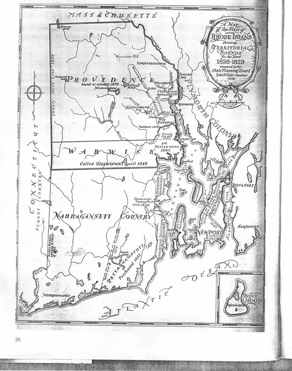
GoldBug maps showing state and county lines of CT, MA & RI in 1703, 1729 and 1862.
Rhode Island in 1902, from the 9th edition of The Encyclopedia Britannica, copyright by Rand McNally, in two sections. Note that Block Island is now part of Washington County, not Newport.
Section 1; Section 2
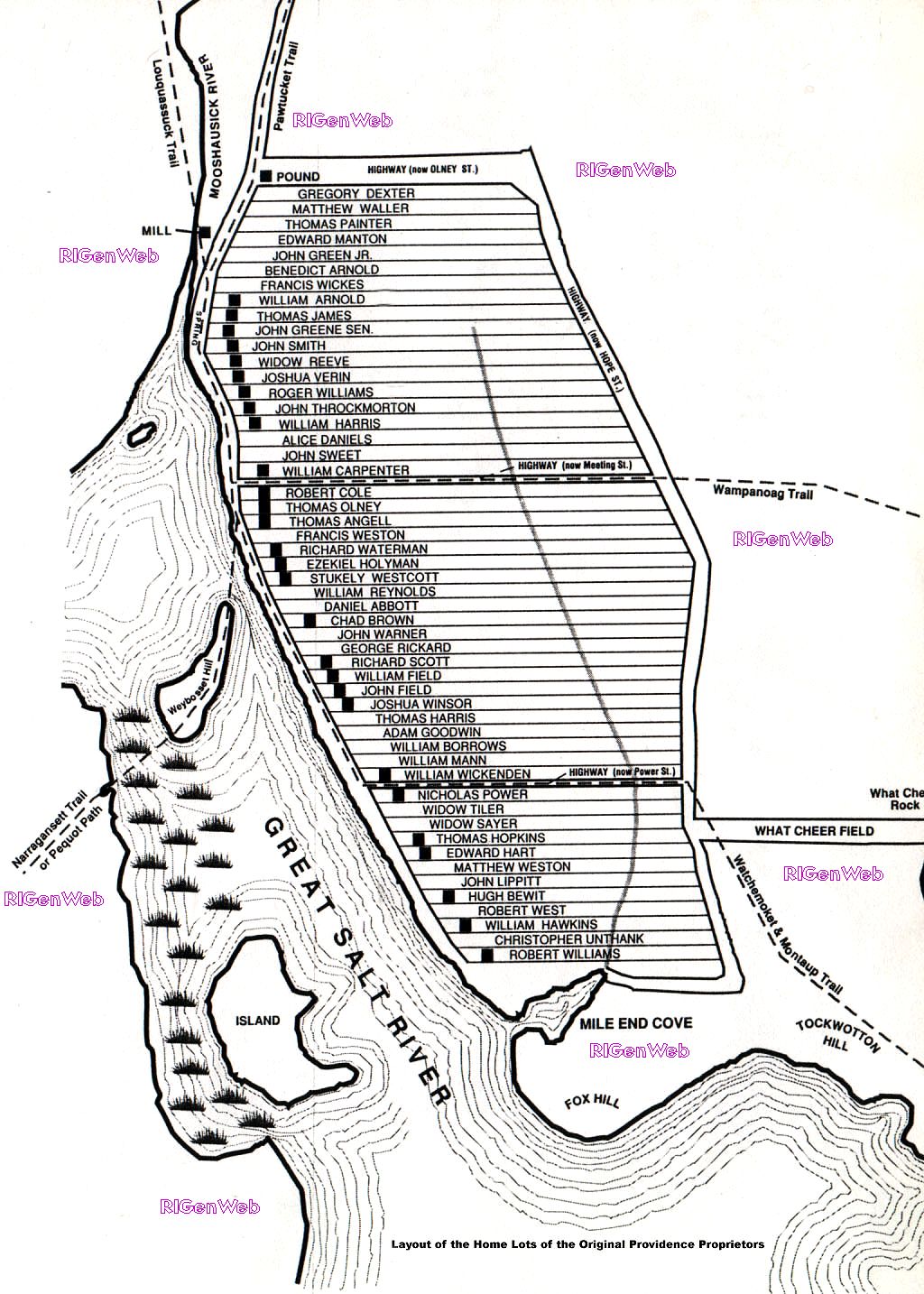
Providence in 1664
In two sections enlarged: Section 1; Section 2Center section enlarged (provided by Sam Behling) to show the names - 295kb.
Names on the map are (in order from top): Gregory Dexter; Matthew Waller; Thomas Painter; Edward Manton; John Greene, Jr.; Benedict Arnold; Francis Wickes; William Arnold; Thomas James; John Greene, Sen.; John Smith; Widow Reeve; Joshua Verin; Roger Williams; John Throckmorton; William Harris; Alice Daniels; John Sweet; William Carpenter; Robert Cole; Thomas Olney; Thomas Angell; Francis Weston; Richard Waterman; Ezekiel Holyman; Stukely Westcott; William Reynolds; Daniel Abbot; Chad Brown; John Warner; George Rickard; Richard Scott; William Field; John Field; Joshua Winsor; Thomas Harris; Adam Goodwin; William Burrows; William Mann; William Wickenden; Nicholas Power; Widow Tiler; Widow Sayer; Thomas Hopkins; Edward Hart; Matthew Weston; John Lippitt; Hugh Bewit [Bewitt]; William Hawkins; Christopher Unthank; Robert Williams.
From the Johnston Town Hall
Owners and Occupants of the Lots, Houses and Shops in the Town of Providence Rhode Island in 1798
From the 9th edition of The Encyclopedia Britannica, copyright by Rand McNally 1902.
City of Providence (enlarged 200%)
1918 Plat Book of the City of Providence Rhode Island

From the Atlas of the State of Rhode Island and Providence Plantations. Compiled and Published by D. G. Beers & Co., 1870
NOTE: All maps are scanned in overlapping sections in a width that can be printed on 8 1/2 wide paper, but may be longer than 11". For best results, save the images and print from an imaging program, rather than your browser.
The scans are numbered beginning at the top left corner and moving across to the right. The next row begins again at the left. For a map that is the size of the book (14" by 16") there will be three sections across for a wide map, and three sections across and two down (six total) for a long map. In order to make the maps legible they have been scanned at full size with a minimal amount of compression. As a result, they will take time to load. Each map, and section of map, has it's own scale.
Providence County 1870
Row one Section 1; Section 2; Section 3East Providence, including an enlargement of Omega: page 13 in six sections:
Row two Section 4; Section 5; Section 6
Row one Section 1; Section 2; Section 3List of names in each section of the East Providence Map: Section 1; Section 2; Section 3; Section 4; Section 5; Section 6.
Row two Section 4; Section 5; Section 6
North Providence: page 25 in three sections
Section 1; Section 2; Section 3List of names in each section of the North Providence Map: Section 1; Section 2; Section 3.
Cranston: page 15 in three sections
Section 1; Section 2; Section 3Johnston Township, including enlargement of Simonsville: page 19 in three sections across:
Section 1; Section 2; Section 3Olneyville, Plain Farm and Silver Lake Plats, Johnston Township: page 21 in three sections across:
List of names in these section
Section 1; Section 2; Section 3Individual enlargements of Allendale, Centerdale, Dyerville, Fruit Hill, Graniteville, Greystone, Hughesdale, Manton Village, and Morgan Mills: page 23 in six sections:
Row one Section 1; Section 2; Section 3Pawtucket : map portion of page 31 in two sections
Row two Section 4; Section 4; Section 6
Section 1; Section 2Smithfield, including enlargements of Ashton, Georgiaville, Greenville, and West Greenville: double page 34 and 35 in six large sections:
Row one Section 1; Section 2; Section 3List of names in each section of the Smithfield Map: Section 1; Section 2; Section 3; Section 4; Section 5; Section 6.
Row two Section 4; Section 5; Section 6
Individual enlargements of Albion, Allenville, Blackstone, Forestdale, [Forrestdale], Manville, Union Village, and Waterford: page 37 in six sections:
Row one Section 1; Section 2; Section 3Cumberland, including enlargements of Cumberland and Lonsdale: page 47 in six sections:
Row two Section 4; Section 5; Section 6
Row one Section 1; Section 2; Section 3Valley Falls: page 49 in six sections:
Row two Section 4; Section 5; Section 6
Row one Section 1; Section 2; Section 3Burrillville: page 51 in three sections:
Row two Section 4; Section 5; Section 6
Section 1; Section 2; Section 3Graniteville, Harrisville, Huntsville, Laurel Hill, Pascoag, Saxonville: page 53 in three sections:
Section 1; Section 2; Section 3Chepachet, Glendale, Harmony, Mapleville, Mohegan, Nasonville: page 55 in six sections:
Row one Section 1; Section 2; Section 3Glocester: page 57 in three sections:
Row two Section 4; Section 5; Section 6
Section 1; Section 2; Section 3Foster: page 59 in six sections:
Row one Section 1; Section 2; Section 3Scituate: page 61 in six sections:
Row two Section 4; Section 5; Section 6
Row one Section 1; Section 2; Section 3North Scituate, including enlargements of New Mill Estate, Hope, Jackson, Arkwright, and Fiskville: page 63 in six sections:
Row two Section 4; Section 5; Section 6
Row one Section 1; Section 2; Section 3Enlargements of Rockland, Richmond, Saundersville, Clayville, Glen Rock, and Pontiac: page 66 in four sections:
Row two Section 4; Section 5; Section 6
Row one Section 1; Section 2
Row two Section 3; Section 4
Providence | Kent | Bristol | Newport | Washington
Kent County 1870
Row one Section 1; Section 2; Section 3Enlargements of Apponaug, Centerville, Crompton, and Natick: page 69 in six sections:
Row two Section 4; Section 5; Section 6
Row one Section 1; Section 2; Section 3Enlargements of Arctic, Birch Hill, Clyde Print Works, Harris, Lippitt, Phenix, and River Point: page 71 in six sections:
Row two Section 4; Section 5; Section 6
Row one Section 1; Section 2; Section 3Coventry and West Greenwich, plus enlargements of Noose Neck and Washington: page 74 and 75 in twelve sections:
Row two Section 4; Section 5; Section 6
Row one Section 1; Section 2; Section 3; Section 4; Section 5; Section 6East Greenwich, plus enlargements of Anthony, Coventry Center, Greene, Quidnick, and Summit: page 77 in six sections:
Row two Section 7; Section 8; Section 9; Section 10; Section 11; Section 12
Row one Section 1; Section 2; Section 3East Greenwich enlarged: page 79 in six sections:
Row two Section 4; Section 5; Section 6
Row one Section 1; Section 2; Section 3
Row two Section 4; Section 5; Section 6
Bristol County 1870
Row one Section 1; Section 2; Section 3Warren: page 83 in six sections:
Row two Section 4; Section 5; Section 6
Row one Section 1; Section 2; Section 3Warren enlarged: page 85 in six sections:
Row two Section 4; Section 5; Section 6
Row one Section 1; Section 2; Section 3Bristol: page 87 in six sections:
Row two Section 4; Section 5; Section 6
Row one Section 1; Section 2; Section 3Bristol enlarged: page 89 in six sections:
Row two Section 4; Section 5; Section 6
Row one Section 1; Section 2; Section 3
Row two Section 4; Section 5; Section 6
Newport County 1870
Row one Section 1; Section 2; Section 3Newport City enlarged: pages 94 and 95 in twelve sections:
Row two Section 4; Section 5; Section 6
Row one Section 1; Section 2; Section 3; Section 4; Section 5; Section 6Block Island and New Shoreham (now Washington County): page 97 in six sections:
Row two Section 7; Section 8; Section 9; Section 10; Section 11; Section 12
Row one Section 1; Section 2; Section 3Little Compton: page 99 in six sections:
Row two Section 4; Section 5; Section 6
Row one Section 1; Section 2; Section 3Tivertons, including enlargements of Stone Bridge, Bridgeport, and Tiverton 4 Corners: page 101 in six sections:
Row two Section 4; Section 5; Section 6
Row one Section 1; Section 2; Section 3Middletown, including enlargements of Little Compton Common and Adamsville: page 103 in six sections:
Row two Section 4; Section 5; Section 6
Row one Section 1; Section 2; Section 3Portsmouth, Prudence and Patience Islands: page 105 in six sections:
Row two Section 4; Section 5; Section 6
Row one Section 1; Section 2; Section 3Jamestown (Connanicut Island), including an enlargement of Newtown, Portsmouth: page 107 in six sections:
Row two Section 4; Section 5; Section 6
Row one Section 1; Section 2; Section 3
Row two Section 4; Section 5; Section 6
Washington County 1870
Row one Section 1; Section 2; Section 3Wickford, plus enlargements of Bellville, LaFayette, Wickford Station: page 111 in six sections:
Row two Section 4; Section 5; Section 6
Row one Section 1; Section 2; Section 3Kingston and Narragansett Pier: page 114 in three sections:
Row two Section 4; Section 5; Section 6
Section 1; Section 2; Section 3South Kingstown: page 115 in six sections:
Row one Section 1; Section 2; Section 3Enlargements of Rocky Brook, Peacedale, and Wakefield: page 117 in six sections:
Row two Section 4; Section 5; Section 6
Row one Section 1; Section 2; Section 3Exeter, plus enlargements of Carolina Mills, Centerville, Moscow, Rockville, Shannock Mills and Woodville: pages 120 and 121 in twelve sections:
Row two Section 4; Section 5; Section 6
Row one Section 1; Section 2; Section 3; Section 4; Section 5; Section 6Richmond: page 123 in six sections:
Row two Section 7; Section 8; Section 9; Section 10; Section 11; Section 12
Row one Section 1; Section 2; Section 3Hopkinton: page 125 in six sections:
Row two Section 4; Section 5; Section 6
Row one Section 1; Section 2; Section 3Enlargements of Ashaway, Hope Valley, Hopkinton City, Laureldale, Locustville, Potters Hill, and Wyoming: page 127 in six sections:
Row two Section 4; Section 5; Section 6
Row one Section 1; Section 2; Section 3Charlestown, plus an enlargement of Dorrville: page 129 in six sections:
Row two Section 4; Section 5; Section 6
Row one Section 1; Section 2; Section 3Westerly, plus enlargements of Lotter Hill, and Watch Hill: page 131 in three long sections:
Row two Section 4; Section 5; Section 6
Section 1; Section 2; Section 3Westerly enlarged, plus Pawcatuck (Stonington, New London, CT): page 133 in six sections:
Row one Section 1; Section 2; Section 3
Row two Section 4; Section 5; Section 6
From The Jonny-Cake Papers of Shepherd Tom by Thomas Robinson Hazard (printed in 1915) who was born in 1797 on the east slope of Tower Hill in Narragansett. The map of "Old Narragansett" was plotted by T. H. Hazard, Jr. and drawn by Norman M. Isham in 1895. Scanned and contributed by Fred Shippee. In eight sections:
Row one Section 1; Section 2; Section 3; Section 4
Row two Section 5; Section 6; Section 7; Section 8
All images, unless otherwise noted, are copyrighted 2000 by Susan Pieroth. They are for individual research use only. They may not be copied to other web pages or otherwise published.
US Census Bureau Statistics for Rhode Island.
Map links & RI Data Centers.
Back to the Rhode Island USGenWeb Home Page