Owners and Occupants of the Lots, Houses and Shops in the Town of Providence Rhode Island in 1798
INTRODUCTION
[Images of pages one, two]
RIGenWeb Project
The historic compilation in the following pages has been made from several sources:
First, the record books at the City hall.
Second, the Acts of Congress approved July 9 and July 14, 1798, and now obsolete - one to provide for the valuation of lands and dwelling-houses and the enumeration of slaves, and the other to lay and collect a direct tax of two million dollars within the United States, and apportioned to the States respectively in the manner following:
New Hampshire $77,705.36 Massachusetts 260,435.31 Rhode Island 37,502.08 Connecticut 129,767.60 Vermont 46,864.18 New York 181,680.77 New Jersey 98,387.25 Pennsylvania 237,177.72 Delaware 30,430.79 Maryland 152,599.95 Virginia 345,488.76 Kentucky 37,643.99 North Carolina 193,697.96 Tennessee 18,806.38 South Carolina 112,997.73 Georgia 38,814.87 The first Act provided for commissioners who were to reside in the district where they served, and were to value and to enumerate every dwelling-house above one hundred dollars in value, with out-houses appurtenant, and the lot on which such dwelling-house and out-houses were erected, not to exceed two acres in any case, such dwelling-house with the lot and appurtenances aforesaid to be valued at the rate they were worth in money, with a due regard to situation.
All lands except the above were to be valued by quantity (acres or square feet) at the average rate which each separate and entire tract or lot was worth in money.
Slaves over the age of 12 and under 50 years of age to be enumerated and assessed 50 cents each.
The commissioners were to require separate and written lists specifying:
First, Dwelling-houses.
Second, Land.
Third, Slaves.In respect to dwelling-houses, the lists to specify:
First, Situation.
Second, Dimensions or area.
Third, Number of stories.
Fourth, Number and dimensions of windows.
Fifth, Materials whether built of wood, brick or stone.
Sixth, Names of owners or occupants.In respect to lands, the lists were to specify the quantity of each tract or lot and dimensions of all wharves and buildings thereon, except dwelling-houses, with the names of the owners or occupants.
The assessment was to be made on the following scale:
$ 100 to $500 2-10 of 1% of the valution
500 to 1,000 3-10 of 1% of the valuation
1,000 to 3,000 4-10 of 1% of the valuation
3,000 to 6,000 1-2 of 1% of the valuation
6,000 to 10,000 6-10 of 1% of the valuation
10,000 to 15,000 7-10 of 1% of the valuation
15,000 to 20,000 8-10 of 1% of the valuation
20,000 to 30,000 9-10 of 1% of the valuation
30,000 and above ..............1%John Dorrance was supervisor of the valuation of the Providence District, and Daniel S. Dexter Collector of Revenue in 1798.
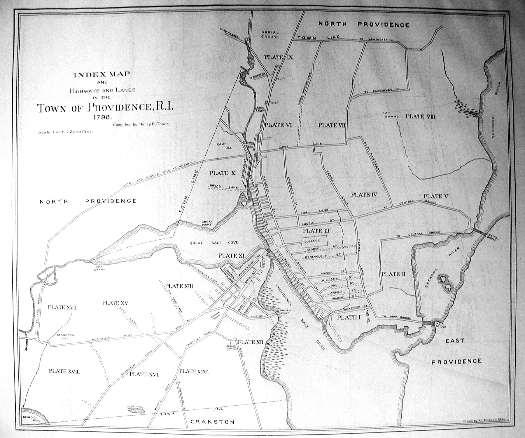
The index map shows the Town of Providence divided into eighteen numbered sections in order in indicate at a glance the part of the town to be examined. The separate plates numbered I-XVIII show that the area on one map overlaps the area on another, and that the east and west lines on Plat One do not exactly coincide with the east and west lines on Plat Two. The same may be said when comparing other plats, all of which is a matter of regret, but the amateur who did the work for his own diversion did not at the time anticipate public examination of the maps.Continued inspection of the plates will show that houses in the old part of the village of Providence were located along the one main highway of the town, which had been called for a hundred years or more the 'Town Street', but in 1798 was called Water, Main, and Constitution Streets, from the south to the north for about two miles. To find where the houses were located on these streets will require the use of Plates I, III and VI.
At right angles to the Town Street and across the Great Bridge, was Weybosset Point. It had been called that since 1638, and had been used for a hundred years as a landing-place for cattle when fording the river in going to and from the village to the farms west and south in the country.
It was marsh-land back from the river for about half a mile, with one crooked cart-road through the marsh leading to Pawtuxet and the west. There were in 1730 but four houses on this point.
This same area is shown on Plate XI in 1798 covered with houses, highways, lanes and wharves. There had been no reclamation of land as there has been since, but there had been a great increase in improvements and inhabitants.
This increase was due to the advant of Deacon Snow and his son, the Parson, combined with the revival of religion of 1744, which caused great unsettlement throughout the New England Colonies and to the great benefit of the Town of Providence.
Plate XII illustrates the tendency of the newcomers to the town to settle in neighborhoods near relatives and former friends.
When the John Field farm was opened for settlement at Cowpen Point, the Eddy family established a shipyard there, and so many of his name were engaged in building vessels and houses that soon the 'Point' was called 'Eddy's neighborhood' or 'Eddy's Point'. South of Eddy's Point, almost to the Cranston line, there was little but salt marsh and river mud.
The same tendency to settle in neighborhoods is shown on Plate XIII in the case of the collection of houses near Ebenezer Knight's Old Store, opposite the junction of the Cranston and Plainfield roads and 'Martha Brown's Tavern', later called 'Hoyle's Tavern'. Ebenezer Knight was the ancestor of Ebenezer Knight Dexter, the benefactor of the Town of Providence, and his house and store had been for seventy years a center of attraction for the farmers.
My desire for diversion has been fully rewarded by the information received while doing this work relating to Old Providence.
I wish the by-product relating to the political, religious and social conditions of the town could be made half as graphic for those curious about the happenings in the town in former days.
It may occur to others to seek relief in extending these researches back to an earlier period, even to the planting of the town. This would be desirable in order to obtain valuable data for a history of Providence for the coming celebration of the three hundredth anniversary of its settlement.
Until after the Revolutionary War, the struggles of the political, social and religious elements of the town were unique, and the effort to extract the facts from the fog of tradition, inexact statement, and prejudice, would be worth making, and the result would be materials to make the early history of Providence more interesting than ever.
Henry R. Chace.
| Owners of land and improvements | 874 |
| Houses occupied by owners | 564 |
| Houses occupied by others | 306 |
| Houses vacant | 24 |
| Not stated | 56 |
| One-story | 206 |
| Two-story | 580 |
| Three-story | 52 |
| Total number of houses | 894 |
| Shops or stores | 185 |
| Wharves | 58 |
| Total area | 2531 1/2 acres |
| Total value | $1,195,923.00 |
| College and Mansion | 2 | Air Furnace | 1 |
| Meeting Houses | Bake Houses | 4 | |
| - Baptist | 1 | Distill Houses | 7 |
| - Presbyterian | 1 | Sugar Houses | 2 |
| - Kings Chapel | 1 | Currier Shops | 4 |
| - Friends Meeting | 1 | Coopers' Shops | 15 |
| - New Light | 1 | Paper Mills | 2 |
| Bank | 1 | Blacksmith Shops | 13 |
| Town House | 1 | Blockmakers | 4 |
| Theatre | 1 | Screw Houses for Hay | 2 |
| Toll Bridges | 2 | Grist Mills | 3 |
| Hospitals (old and new) | 2 | Old Dye House | 1 |
| Burying Grounds | 5 | Ice House | 1 |
| Rope Walks | 4 | Stone Ware Kiln | 1 |
| Tanyards | 3 | Old Oil Works | 1 |
| Bark Houses | 3 | Soap Shop | 1 |
| Slaughter Houses | 6 | Ship Yard | 1 |
| Parsonage | 1 | Mill Site | 1 |
| Exchange Coffee House | 1 | Salt Shed | 1 |
| Fulling Mill | 1 | Other shops used by carpenters, weavers, printers, etc. ..... | 110 |
Back to the RIGenWeb Map Page